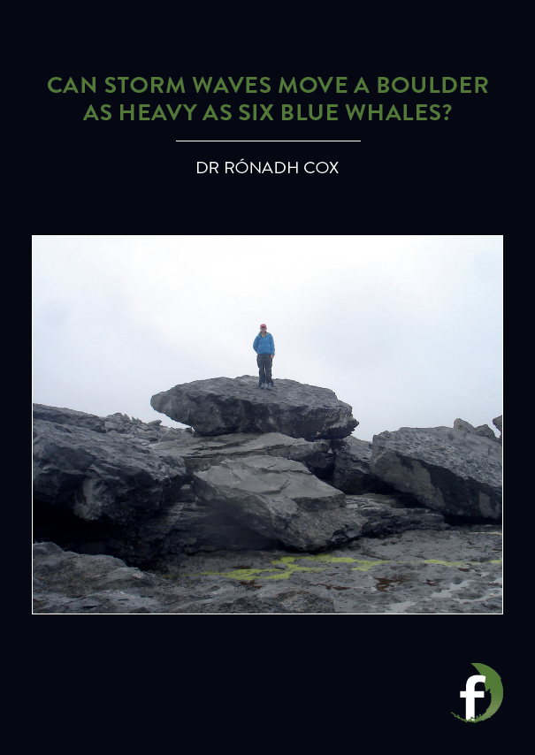
Can storm waves move a boulder as heavy as six blue whales?
HOW DID RÓNADH’S TEAM PROVE THE ROCKS HAD MOVED?
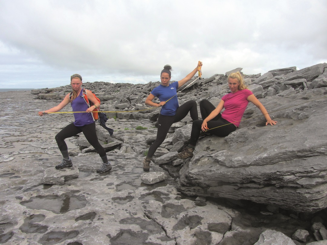
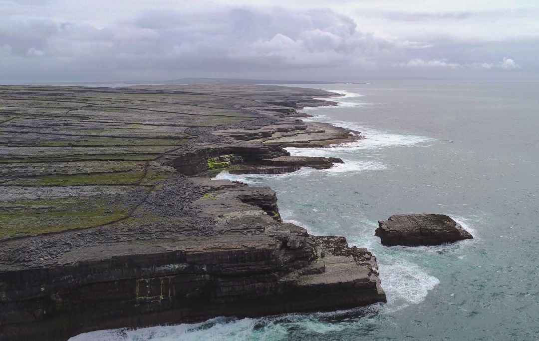
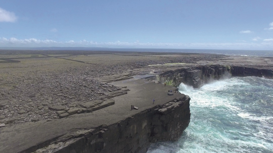
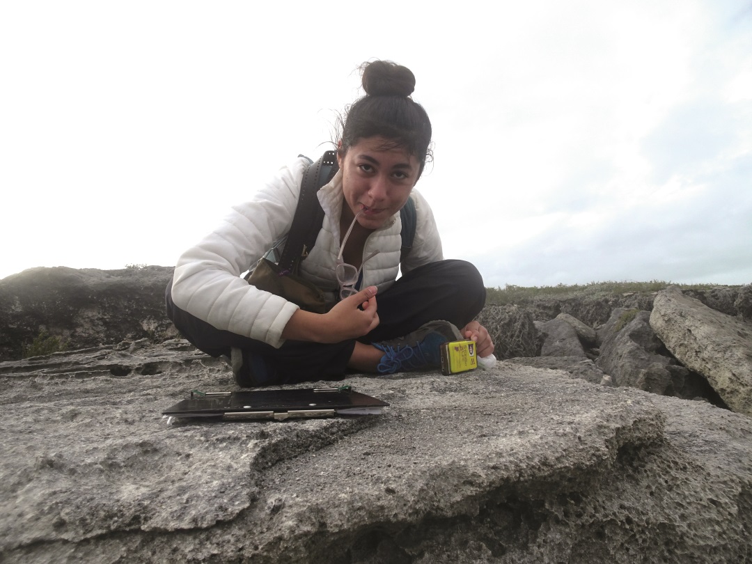
The key evidence came from before-and-after photographs that were linked to map locations. Back in 2008, Rónadh visited the area with a student, Danielle Zentner, to study the boulders. They were looking for hard evidence of whether tsunami or storm waves had moved these huge rocks, and so they began to measure, photograph and map the locations of boulder deposits on the Aran Islands. More students took an interest in the project, and over the years they gathered key information, including the weight and precise locations of thousands of boulders, and photographed them.
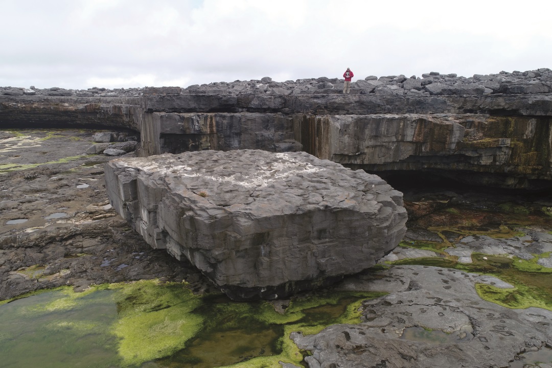
After the big storms hit the west coast of Ireland in 2013-14, Rónadh returned to the Aran Islands with a team of seven students. This time, they were armed with photographs and measurements. The research team visited all of the sites and compared the photographs they had from previous years (on iPads) with the locations of boulders. It was apparent that many boulders hadn’t moved. But many others had: some had travelled 10s of metres, some had been hoisted up and over other boulders, and some had disappeared entirely! In places, solid bedrock had been ripped up to make new boulders.
“We were able to make graphs – simple XY plots – showing relationships between boulder weight and distance inland, height above sea level, and coast steepness – and also between those topographic variables and the distance the boulders moved. These are very basic measurements and diagrams (not rocket science!), but nobody had shown these relationships before,” explains Rónadh.
WHY DID PEOPLE THINK A TSUNAMI HAD MOVED THESE BOULDERS?
“Storm waves have shorter periods than tsunami,” says Rónadh. The period is the amount of time a wave takes to pass a point. Big storm waves can take 10-15 seconds, but a tsunami is much longer, lasting many minutes. Tsunamis are destructive because the flow of water continues for a long time, engulfing and pushing objects as it goes. But because storm waves at the coast form surf that flows in and out in just a few seconds, people thought they lacked the sustained force to dislocate giant blocks. Thanks to Rónadh and her students, we now understand more about the power storm waves and surf can exert.
WHY IS IT IMPORTANT TO STUDY BOULDER MOVEMENT?
Scientists have been studying transport of sand and small rocks on coastlines for a long time, so we know lots about the impact of storms on beaches in coastal areas where people live. These places tend to experience lower-energy waves compared to areas such as the Aran Islands. But as sea level rises, and climates change, it’s possible that storminess may increase. We therefore need to understand the highest wave energies, to understand how much coastal damage storm systems can cause.
Before Rónadh’s research was published, people didn’t realise that storm waves could move boulders as heavy as six blue whales – or heavier. The largest boulder on the Aran Islands weighs more than 700 tonnes. It didn’t move during the 2013-14 storms, but evidence shows that it moved in the past. If scientists are to accurately understand and predict risks associated with living in coastal areas, understanding boulder transport is vital. And the world needs more geologists to work on these problems!
Check out this video created by Ava Palmo, one of Rónadh’s students. In this video, entitled ‘MegaGravel’, you’ll meet residents of the Aran Islands, and see spectacular aerial views of the coastline.
WHAT DID YOU WANT TO BE WHEN YOU WERE YOUNGER?
I always wanted to work in the natural world. I was fascinated by stories of adventure and exploration, and also by animals. Initially, I wanted to be a marine scientist or a biologist.
SO, HOW DID YOU END UP FOLLOWING IN CAREER IN GEOLOGY?
I went to college planning to get a degree in biology and hoping to have a career that would involve adventure and exploration outdoors. I took geology as my fourth course because I didn’t want to do physics (I’ve always been shy of maths, although over the years I’ve discovered that maths is pretty badass!) It didn’t take long, just a few weeks, before I was sucked in by the concepts of plates, earthquakes, deep time and the way the earth works.
Reference
https://doi.org/10.33424/FUTURUM07

HOW DID RÓNADH’S TEAM PROVE THE ROCKS HAD MOVED?
The key evidence came from before-and-after photographs that were linked to map locations. Back in 2008, Rónadh visited the area with a student, Danielle Zentner, to study the boulders. They were looking for hard evidence of whether tsunami or storm waves had moved these huge rocks, and so they began to measure, photograph and map the locations of boulder deposits on the Aran Islands. More students took an interest in the project, and over the years they gathered key information, including the weight and precise locations of thousands of boulders, and photographed them.
After the big storms hit the west coast of Ireland in 2013-14, Rónadh returned to the Aran Islands with a team of seven students. This time, they were armed with photographs and measurements. The research team visited all of the sites and compared the photographs they had from previous years (on iPads) with the locations of boulders. It was apparent that many boulders hadn’t moved. But many others had: some had travelled 10s of metres, some had been hoisted up and over other boulders, and some had disappeared entirely! In places, solid bedrock had been ripped up to make new boulders.
“We were able to make graphs – simple XY plots – showing relationships between boulder weight and distance inland, height above sea level, and coast steepness – and also between those topographic variables and the distance the boulders moved. These are very basic measurements and diagrams (not rocket science!), but nobody had shown these relationships before,” explains Rónadh.
WHY DID PEOPLE THINK A TSUNAMI HAD MOVED THESE BOULDERS?
“Storm waves have shorter periods than tsunami,” says Rónadh. The period is the amount of time a wave takes to pass a point. Big storm waves can take 10-15 seconds, but a tsunami is much longer, lasting many minutes. Tsunamis are destructive because the flow of water continues for a long time, engulfing and pushing objects as it goes. But because storm waves at the coast form surf that flows in and out in just a few seconds, people thought they lacked the sustained force to dislocate giant blocks. Thanks to Rónadh and her students, we now understand more about the power storm waves and surf can exert.
WHY IS IT IMPORTANT TO STUDY BOULDER MOVEMENT?
Scientists have been studying transport of sand and small rocks on coastlines for a long time, so we know lots about the impact of storms on beaches in coastal areas where people live. These places tend to experience lower-energy waves compared to areas such as the Aran Islands. But as sea level rises, and climates change, it’s possible that storminess may increase. We therefore need to understand the highest wave energies, to understand how much coastal damage storm systems can cause.
Before Rónadh’s research was published, people didn’t realise that storm waves could move boulders as heavy as six blue whales – or heavier. The largest boulder on the Aran Islands weighs more than 700 tonnes. It didn’t move during the 2013-14 storms, but evidence shows that it moved in the past. If scientists are to accurately understand and predict risks associated with living in coastal areas, understanding boulder transport is vital. And the world needs more geologists to work on these problems!
Check out this video created by Ava Palmo, one of Rónadh’s students. In this video, entitled ‘MegaGravel’, you’ll meet residents of the Aran Islands, and see spectacular aerial views of the coastline.
WHAT DID YOU WANT TO BE WHEN YOU WERE YOUNGER?
I always wanted to work in the natural world. I was fascinated by stories of adventure and exploration, and also by animals. Initially, I wanted to be a marine scientist or a biologist.
SO, HOW DID YOU END UP FOLLOWING IN CAREER IN GEOLOGY?
I went to college planning to get a degree in biology and hoping to have a career that would involve adventure and exploration outdoors. I took geology as my fourth course because I didn’t want to do physics (I’ve always been shy of maths, although over the years I’ve discovered that maths is pretty badass!) It didn’t take long, just a few weeks, before I was sucked in by the concepts of plates, earthquakes, deep time and the way the earth works.
I went to University College Dublin and had never lived anywhere else. When I decided to do a PhD, I thought it would be fun to live and work in a foreign country, so I applied to universities in the US. I had planned to come home to Ireland after I got my degree, but I met my husband in graduate school. He’s also a geologist, and we both wanted to work in research and teaching. The US is where we both managed to find college jobs.
YOU’RE CURRENTLY BASED AT WILLIAMS COLLEGE, IN MASSACHUSETTS, USA. WHY ARE YOU STUDYING BOULDERS ON THE WEST COAST OF IRELAND?
My motto is: ‘The whole world is made of rock. Why not study it someplace interesting?’ Geoscience is a ticket to anywhere and everywhere. I’m studying the west coast of Ireland because it turns out that its boulders are some of the most impressive in the world.
WHAT DO YOU LOVE MOST ABOUT YOUR JOB? AND WHAT ARE YOU NOT SO KEEN ON?
I love field research. I love teaching students. I especially love teaching students in the field. I love solving puzzles about how the Earth works. I love that I get to walk along some of the most beautiful coastlines in the world, and that I get paid to do it! #theWorldIsMyOffice. I don’t like grading and I don’t like administrative work, but you gotta do what you gotta do.
IF YOU COULD GO BACK IN TIME WHAT ADVICE WOULD YOU GIVE YOURSELF WHEN YOU WERE STARTING OUT ON YOUR CAREER PATH?
Take chances! Don’t be afraid to make mistakes or to fail. But own your mistakes and your failures; learn from them and move on. Your failures don’t define you, but they can make you stronger and help you create your successes. It took me six years to get my four-year degree because I failed courses and made bad choices and prioritised social life over work. But I learned, I grew up, and here I am. It’s all good!
 DR RÓNADH COX
Edward Brust Professor of Geology and Minerology
Williams College, USA
FIELD OF RESEARCH: Geology
RESEARCH PROJECT: Rónadh and her team of students have measured, photographed and documented the location of over 1,100 giant boulders that were moved by storms on the west coast of Ireland. Her work has helped prove that storm waves can move rocks weighing hundreds of tonnes.
FUNDERS: National Science Foundation and Williams College Class of 1963 Sustainability Fund
DR RÓNADH COXEdward Brust Professor of Geology and Minerology
Williams College, USA
FIELD OF RESEARCH: Geology
RESEARCH PROJECT: Rónadh and her team of students have measured, photographed and documented the location of over 1,100 giant boulders that were moved by storms on the west coast of Ireland. Her work has helped prove that storm waves can move rocks weighing hundreds of tonnes.
FUNDERS: National Science Foundation and Williams College Class of 1963 Sustainability Fund
01 – Go to college and take an introductory geology or geoscience class (they’re the same thing). That will put your feet on the path, and that path can take you anywhere – literally. The whole world is made of rocks!
02 – Talk to a geologist. If you don’t know any, find one or two on Google and send them an email. Most of us are happy to talk to people who are interested in the planet and want to know what a geoscientist does.
Rónadh has been studying and working in geology for nearly 40 years. We ask her why becoming a geologist is a good career choice.
WHY DO WE NEED GEOLOGISTS?
Lots of reasons! But here are a couple. First, most of our natural resources come from the Earth. As the saying goes: ‘If it can’t be grown, it must be mined’. From the metal in your fizzy drink can, to the necklace around your neck, to the 70+ components in a computer screen, a geologist had to figure out where to find the ores to create all these things.
Second, we live in a dynamic world, subject to floods, landslides, earthquakes and eruptions. Geologists are the people who try to understand these processes, and help communities decide how to manage natural hazards and where to build.
WOULD YOU SAY GEOLOGY, OR THE GEOSCIENCES, OFFER GOOD JOB PROSPECTS?
Very much so. You can get a geology job with just a bachelor’s degree. And if you decide to pursue an advanced degree, you can get paid to do that. Students are awarded fellowships to cover tuition costs and are paid a salary. Graduates go into teaching, environmental engineering, resource exploration, conservation, management, climate science – all kinds of things. Some even use their geology background to kick start careers in law or politics.
WHAT EXCITES YOU ABOUT YOUR RESEARCH AND GEOLOGY, MORE GENERALLY?
Geoscience teaches us to look at the planet and ask questions. I love to walk around wondering how things formed. People who know geologists joke that you should never drive with them, because they spend all their time looking out of the window at rocks instead of watching the road. Geology makes the world come alive!
- According to GlassDoor, geologists with just a bachelor’s degree earn $63,000 on average.
- Some industries pay more. For example, government geologists earn on average $103,000 or more (FederalPay.org), and geologists in the oil industry earn on average $150,000 per year.
- Lots of employers seek people with a degree in geoscience. The energy sector (oil, gas, wind, waves) and environmental firms hire geologists, but there are also opportunities elsewhere. The National Park Service, for example, offers paid internships for college students and recent graduates.
- It’s important to remember that students enrolled in geoscience PhD programmes are usually paid while studying for their degree (see PhD Stipends).
Hi there! This post couldn’t be written any better!
Going through this post reminds me of my previous roommate!
He always kept preaching about this. I will forward
this information to him. Fairly certain he will have a very good
read. Thanks for sharing!