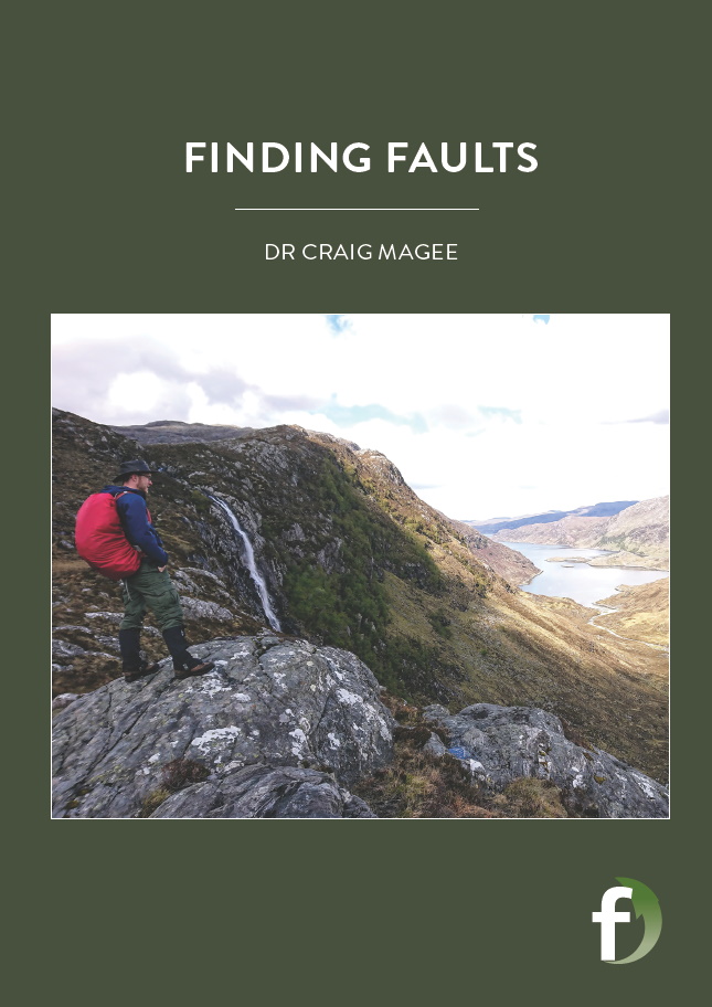
Finding faults
Volcanoes are fed by magma that rises through cracks in the Earth’s crust, but we do not really understand how these cracks form and what they tell us about the risks of volcanic eruptions. Dr Craig Magee, from the University of Leeds in the UK, is trying to see below the earth’s surface to learn more
TALK LIKE A STRUCTURAL GEOLOGIST
FAULT – where an earthquake creates a crack through the Earth’s crust, offsetting the rocks on either side
GRABEN – valleys created by faults
MAGMA – molten rock
DYKE – a vertical crack in the crust, which transports magma
SEISMIC REFLECTION – firing sound waves into the crust and measuring the reflections from different layers of rock
LIDAR – Light Detection and Ranging: bouncing lasers off a surface and measuring the reflections to see how far away it is
DYKE INJECTION – the injection of magma into a dyke
Volcanoes are a major, and often unpredictable, natural hazard. Millions of people around the world live in areas directly at risk from volcanic eruptions, and many more can be indirectly affected by hazards such as large ash clouds generated by volcanoes. Dr Craig Magee, a structural geologist at the University of Leeds, is researching how magma moves through the crust to erupt at the surface. Through this research, he hopes to improve methods for predicting volcanic eruptions and answer important questions about how volcanoes form on Earth and on other planets.
WHAT ARE DYKES AND DYKE-INDUCED FAULTS?
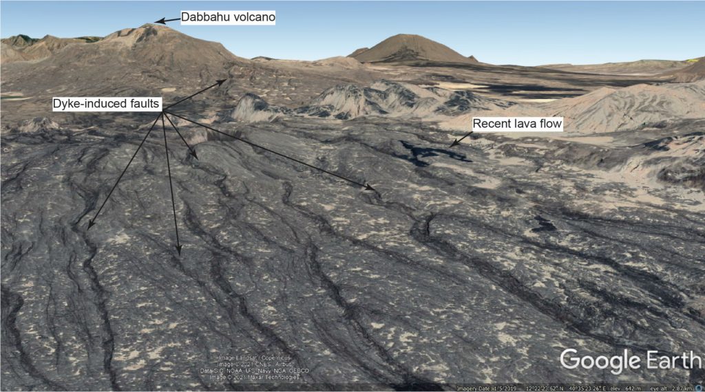
Dykes are vertical cracks in the Earth’s crust, which transport magma from depth up towards the surface, where it may erupt at volcanoes. However, most dykes stop before they reach the surface. Instead, they create two faults which extend from the surface down to the top of the dyke, forming a ‘V’ shape, with the point of the V at the top of the dyke. These are dyke-induced faults. The rock between the two faults slips down relative to the rocks outside, forming a valley at the surface. These fault-created valleys, called graben, are seen in many volcanically active areas on Earth, such as Hawaii, Iceland and Ethiopia. The goal of Craig’s research is to use the structure of dyke-induced faults to understand where magma is moving below the surface and how much of it there is. This information can then be used to predict where volcanic eruptions are most likely to take place.
Currently, we have a lot of information about what dyke-induced faults look like at the surface of the Earth, but we do not really know what they look like underground. We have experimental and computer models of what dyke-induced faults might look like, but as Craig explains, “the biggest challenge with creating models is finding ways to test them”. Dykes and faults are narrow structures, often only a metre or two wide, and buried hundreds of metres below the surface, so we need advanced imaging techniques to see what is happening to these underground structures.
HOW DOES CRAIG IMAGE DYKE-INDUCED FAULTS BELOW THE SURFACE?
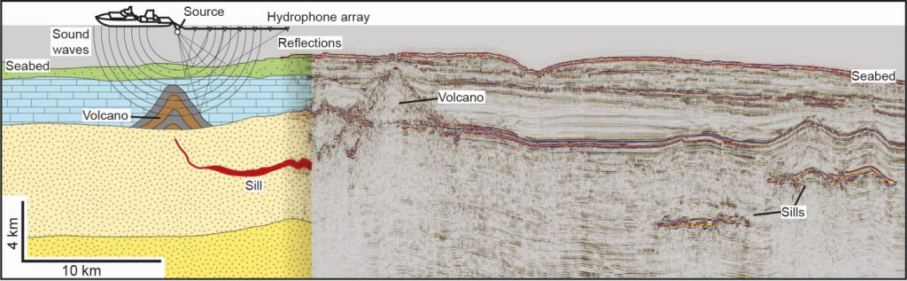
Craig uses a technique called 3D seismic reflection to image underground structures. This uses the same principles as a medical ultrasound scan, but involves firing sound waves down into the Earth’s crust and recording when reflections from boundaries between different rock layers arrive back at the surface. Since dyke-induced faults produce breaks in the rock layers, seismic reflection can image the rock layers and see where the offsets are, allowing us to map the position of the faults. Craig has discovered that while most models assume that dyke-induced faults are straight, the real faults that he has imaged are actually very jagged. So, the simple assumptions that we used to predict what the faults look like beneath the surface actually turned out to be wrong.
HOW DOES THIS RELATE TO FAULTS AT THE SURFACE?
Although seismic reflection produces images of the sub-surface, we cannot study the rocks below the surface directly to test our interpretations of the data. Craig is also studying recently formed faults in Ethiopia, where lots of active volcanism and faulting takes place, to see if the same jagged structures are present there. To do this, he is using a technique called LiDAR, which uses laser scanning to make maps of the ground elevation, which are accurate to within a few centimetres. He is using two maps of the same area in Ethiopia where there are active faults. In the time between the two maps being produced, there was a dyke injection event and some of the faults moved. By comparing the maps before and after the event, he can make a high-resolution map of where fault movement occurred. By combining this information with other geophysical data, such as the location and depth of earthquakes, Craig can map out the sub-surface structure of the faults and see how they grow during dyke injection events.
WHAT ABOUT GEOLOGY ON OTHER PLANETS?
Graben are found on the surface of several planets and moons in the Solar System, and we know that these bodies have had volcanism in the past so we think they were formed by dyke-induced faulting. However, we have very few ways of investigating the sub-surface of other planets, so it is only by studying how dyke-induced faulting occurs on Earth that we can infer what may be going on beneath the surface on other planets. Using the 3D seismic reflection data, Craig has also found structures called pit craters, associated with the dyke-induced faults. This was the first time these features have been identified on seismic images and studied in 3D. Pit craters are common on other planets and there are many theories about how they had formed – Craig’s discovery suggests that dyke-induced faulting may be the cause. They have often been suggested as potential landing sites for crewed missions to other planets, but so little is known about them that it is difficult to assess whether they would be a good choice.
HOW DOES THIS WORK BENEFIT WIDER SOCIETY?
Dykes form part of a network of pathways and reservoirs which feed magma from the deep crust to volcanoes at the surface. These magma plumbing systems are where many of the metal deposits that our society relies on are formed. In particular, many of the key metals that we need for a sustainable future come from magma systems, so understanding how they form is essential for improving mineral exploration and extraction.
Another big motivation for Craig’s work on dykes is that it feeds into our understanding of volcano monitoring and eruption prediction. Dykes carry the magma to the surface prior to an eruption, so monitoring dyke activity to see if new magma is rising to the surface is an important aspect of volcano monitoring. The main existing techniques for this involve recording earthquakes and surface elevation changes, both of which are caused by dyke-induced faulting. So, Craig’s work helps to improve our models of magma movement. Understanding where faults are likely to break the surface is also important when building infrastructure, such as roads and bridges. Craig illustrates the diverse range of problems that geologists can find themselves tackling, from fundamental questions about how the Earth and other planets formed, to critical resource production, to practical ways to reduce risks from natural hazards.
Reference
https://doi.org/10.33424/FUTURUM189
FAULT – where an earthquake creates a crack through the Earth’s crust, offsetting the rocks on either side
GRABEN – valleys created by faults
MAGMA – molten rock
DYKE – a vertical crack in the crust, which transports magma
SEISMIC REFLECTION – firing sound waves into the crust and measuring the reflections from different layers of rock
LIDAR – Light Detection and Ranging: bouncing lasers off a surface and measuring the reflections to see how far away it is
DYKE INJECTION – the injection of magma into a dyke
Volcanoes are a major, and often unpredictable, natural hazard. Millions of people around the world live in areas directly at risk from volcanic eruptions, and many more can be indirectly affected by hazards such as large ash clouds generated by volcanoes. Dr Craig Magee, a structural geologist at the University of Leeds, is researching how magma moves through the crust to erupt at the surface. Through this research, he hopes to improve methods for predicting volcanic eruptions and answer important questions about how volcanoes form on Earth and on other planets.
WHAT ARE DYKES AND DYKE-INDUCED FAULTS?
Dykes are vertical cracks in the Earth’s crust, which transport magma from depth up towards the surface, where it may erupt at volcanoes. However, most dykes stop before they reach the surface. Instead, they create two faults which extend from the surface down to the top of the dyke, forming a ‘V’ shape, with the point of the V at the top of the dyke. These are dyke-induced faults. The rock between the two faults slips down relative to the rocks outside, forming a valley at the surface. These fault-created valleys, called graben, are seen in many volcanically active areas on Earth, such as Hawaii, Iceland and Ethiopia. The goal of Craig’s research is to use the structure of dyke-induced faults to understand where magma is moving below the surface and how much of it there is. This information can then be used to predict where volcanic eruptions are most likely to take place.
Currently, we have a lot of information about what dyke-induced faults look like at the surface of the Earth, but we do not really know what they look like underground. We have experimental and computer models of what dyke-induced faults might look like, but as Craig explains, “the biggest challenge with creating models is finding ways to test them”. Dykes and faults are narrow structures, often only a metre or two wide, and buried hundreds of metres below the surface, so we need advanced imaging techniques to see what is happening to these underground structures.
HOW DOES CRAIG IMAGE DYKE-INDUCED FAULTS BELOW THE SURFACE?
Craig uses a technique called 3D seismic reflection to image underground structures. This uses the same principles as a medical ultrasound scan, but involves firing sound waves down into the Earth’s crust and recording when reflections from boundaries between different rock layers arrive back at the surface. Since dyke-induced faults produce breaks in the rock layers, seismic reflection can image the rock layers and see where the offsets are, allowing us to map the position of the faults. Craig has discovered that while most models assume that dyke-induced faults are straight, the real faults that he has imaged are actually very jagged. So, the simple assumptions that we used to predict what the faults look like beneath the surface actually turned out to be wrong.
HOW DOES THIS RELATE TO FAULTS AT THE SURFACE?
Although seismic reflection produces images of the sub-surface, we cannot study the rocks below the surface directly to test our interpretations of the data. Craig is also studying recently formed faults in Ethiopia, where lots of active volcanism and faulting takes place, to see if the same jagged structures are present there. To do this, he is using a technique called LiDAR, which uses laser scanning to make maps of the ground elevation, which are accurate to within a few centimetres. He is using two maps of the same area in Ethiopia where there are active faults. In the time between the two maps being produced, there was a dyke injection event and some of the faults moved. By comparing the maps before and after the event, he can make a high-resolution map of where fault movement occurred. By combining this information with other geophysical data, such as the location and depth of earthquakes, Craig can map out the sub-surface structure of the faults and see how they grow during dyke injection events.
WHAT ABOUT GEOLOGY ON OTHER PLANETS?
Graben are found on the surface of several planets and moons in the Solar System, and we know that these bodies have had volcanism in the past so we think they were formed by dyke-induced faulting. However, we have very few ways of investigating the sub-surface of other planets, so it is only by studying how dyke-induced faulting occurs on Earth that we can infer what may be going on beneath the surface on other planets. Using the 3D seismic reflection data, Craig has also found structures called pit craters, associated with the dyke-induced faults. This was the first time these features have been identified on seismic images and studied in 3D. Pit craters are common on other planets and there are many theories about how they had formed – Craig’s discovery suggests that dyke-induced faulting may be the cause. They have often been suggested as potential landing sites for crewed missions to other planets, but so little is known about them that it is difficult to assess whether they would be a good choice.
HOW DOES THIS WORK BENEFIT WIDER SOCIETY?
Dykes form part of a network of pathways and reservoirs which feed magma from the deep crust to volcanoes at the surface. These magma plumbing systems are where many of the metal deposits that our society relies on are formed. In particular, many of the key metals that we need for a sustainable future come from magma systems, so understanding how they form is essential for improving mineral exploration and extraction.
Another big motivation for Craig’s work on dykes is that it feeds into our understanding of volcano monitoring and eruption prediction. Dykes carry the magma to the surface prior to an eruption, so monitoring dyke activity to see if new magma is rising to the surface is an important aspect of volcano monitoring. The main existing techniques for this involve recording earthquakes and surface elevation changes, both of which are caused by dyke-induced faulting. So, Craig’s work helps to improve our models of magma movement. Understanding where faults are likely to break the surface is also important when building infrastructure, such as roads and bridges. Craig illustrates the diverse range of problems that geologists can find themselves tackling, from fundamental questions about how the Earth and other planets formed, to critical resource production, to practical ways to reduce risks from natural hazards.
 DR CRAIG MAGEE
NERC Independent Research Fellow, University of Leeds, UK
FIELD OF RESEARCH: Structural Geology
RESEARCH PROJECT: Investigating the structure of dyke-induced faults to understand how magma is supplied to volcanoes and how to monitor their risks of eruption better
FUNDER: Natural Environment Research Council (Project grant number: NE/R014086/1)
DR CRAIG MAGEE
NERC Independent Research Fellow, University of Leeds, UK
FIELD OF RESEARCH: Structural Geology
RESEARCH PROJECT: Investigating the structure of dyke-induced faults to understand how magma is supplied to volcanoes and how to monitor their risks of eruption better
FUNDER: Natural Environment Research Council (Project grant number: NE/R014086/1)
ABOUT STRUCTURAL GEOLOGY
Geology is the study of rocks: how they are formed, how they change over time, and how this knowledge can be applied to solve human problems. Rocks provide the historical record which we have interpreted to provide us with the evidence for the evolution of life, plate tectonics and past climate changes. They are also the source of the metals and many other raw materials that our society needs. Geology brings together many different skills, from studying and collecting rocks in the field, to advanced chemical analyses to computer modelling.
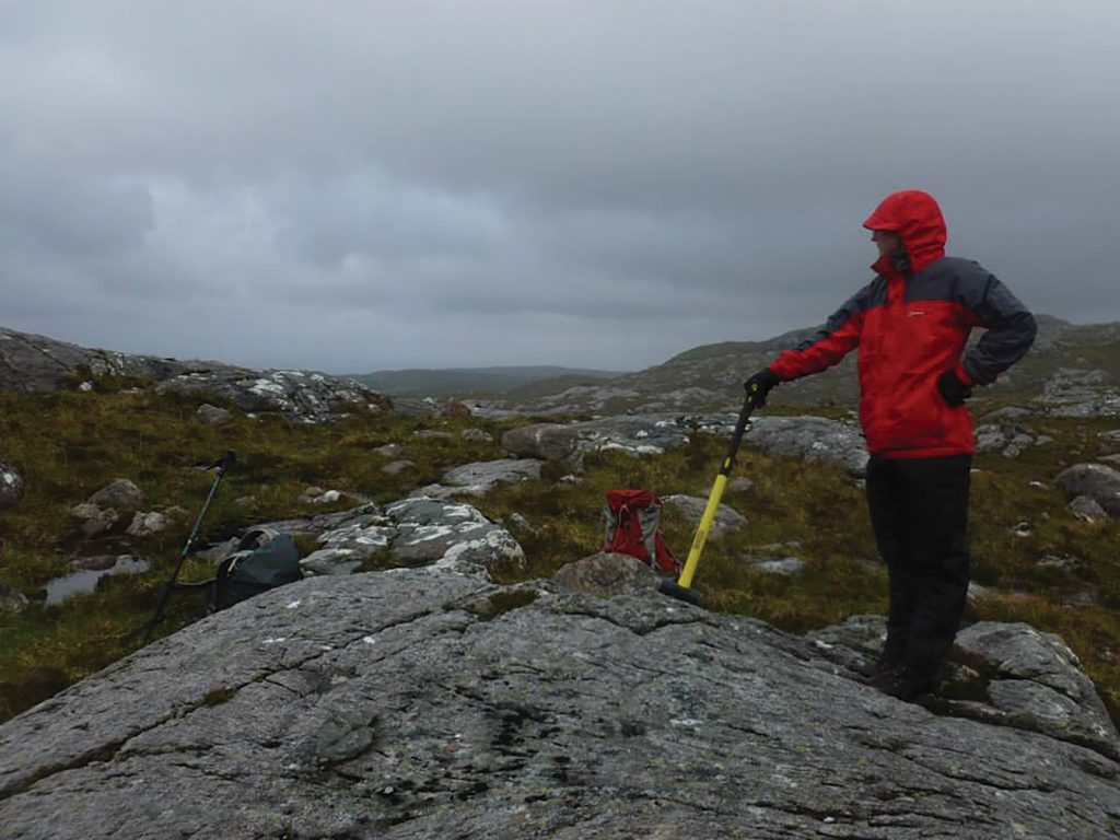
Day to day life as a geologist is very varied. Some days you might be looking through datasets on a computer, finding new things that nobody has looked at before. Other days, you might be in a lab, building new experiments to model your rocks, or carrying out chemical analyses. Communicating your research to others is an important part of being a scientist, so you also spend a lot of time writing papers and making presentations that will inform other scientists about your new findings. The best days are usually when you get to go out and look at rocks in the field, trying to build a picture of what is going on beneath your feet from what you see at the surface.
“Science is incredibly fulfilling in terms of travel, whether it’s physically or virtually,” says Craig. “I have met so many wonderful people from everywhere around the world, and visited places no tourist goes. The experiences are incredibly humbling and an inspiration of how the world should be: connected, with everyone getting on. I collaborate with people all over the world. The sharing of ideas and knowledge is one of the best aspects of being a scientist.”
As a geologist at a university, you also spend part of your time teaching students to educate the next generation of geologists. You start out as the expert teaching them, but by the end of their projects they know more about their work than you do, which can be very fulfilling, and a great learning experience for you as well.
EXPLORE A CAREER IN STRUCTURAL GEOLOGY
• The easiest place to start is social media – there are so many great scientists talking about their work on Twitter and sharing photos of amazing geology. Craig (@DrCraigMagee) recommends following @seis_matters, @mcnamadd, @inthevolcano, @ThePlanetaryGuy, @KeepItRehol, @Virtualgeol, to name a few. Social media is also where you can easily find out about geological events and societies near you.
• The Geological Society has a great website full of useful careers-related information: www.geolsoc.org.uk/Geology-Career-Pathways/Careers
• Many universities have outreach programmes, where their staff visit schools and showcase different subjects. Visit the University of Leeds’ website to find out about studying geology: www.stem.leeds.ac.uk/earthsciences/
The site also includes taster lecture videos: www.stem.leeds.ac.uk/earthsciences/environment-taster-lecture-videos/
• The salary for a geologist is quite variable depending on which area you specialise in, but £25,000-£35,000 is not uncommon for early career positions, and that can rise significantly with experience.
• Craig says, “I did geology, geography, biology and economics at A-Level. But to be honest, I think anyone can go into geology. It’s a subject that involves all the sciences and there are plenty of opportunities to bring in art, computing, anything you like really! Anyone can find a part of geology that they enjoy and are good at.”
• Many schools do not offer geology A-level but do not let this put you off. People go into geology with a wide range of science subjects.
HOW DID CRAIG BECOME A STRUCTURAL GEOLOGIST?
WHAT WERE YOUR INTERESTS WHEN YOU WERE GROWING UP?
I spent most my time playing football and computer games. I do remember loving dinosaurs, fossil hunting, and minerals at various times though.
WHO OR WHAT INSPIRED YOU TO BECOME A SCIENTIST? WHAT MOTIVATES YOUR WORK TODAY?
Nothing really! I just followed doing what I enjoyed, from physical geography at GCSE to geology at A-Level. I’m incredibly grateful to the support from family and teachers though. As for today’s motivation, I love my job and enjoy most aspects of it. As we spend most of our lives working, I figured I may as well do something I enjoy.
WHAT ATTRIBUTES HAVE MADE YOU SUCCESSFUL AS A SCIENTIST?
There’s a misconception that scientists are great at maths; I’m useless at it! I think the key attribute for a successful scientist is being able to admit your weaknesses and find people to work with who complement them.
TO WHAT EXTENT DOES YOUR LOVE OF GEOLOGY SPILL OVER INTO YOUR FREE TIME?
I love geology because it offers a whole new perspective on the landscape around you. You go to a scenic spot and whilst most people enjoy the view, you get to enjoy seeing how it evolved over millions, or even billions, of years.
WHAT ARE YOUR PROUDEST CAREER ACHIEVEMENTS SO FAR? WHAT ARE YOUR AMBITIONS FOR THE FUTURE?
I have won several awards, which I am proud of, but I think my proudest achievement was helping a student write up their project as a paper for a new journal called Volcanica, which is freely accessible to everyone everywhere. We have the first paper in the journal – issue 1, volume 1, page 1! (You can read it at: www.jvolcanica.org/ojs/index.php/volcanica/article/view/2)
CRAIG’S TOP TIPS
01 Find something you enjoy and keep at it. Don’t be afraid to change your mind or admit you’re wrong; we learn most from our mistakes.
02 Earth science is a very broad field so anyone can find a part of Earth science that they enjoy and are good at, no matter their background.
Do you have a question for Craig?
Write it in the comments box below and Craig will get back to you. (Remember, researchers are very busy people, so you may have to wait a few days.)