Can we reveal Earth’s secrets by dating faults?
Understanding the Earth’s geological history is crucial, not only for revealing its hidden evolutionary past but also for predicting future events. Dr Dawn Kellett, a research scientist at the Geological Survey of Canada, focuses on methods to accurately determine the ages of geological faults, providing invaluable insights into Earth’s geological evolution.
Talk like a geochronologist
Decay — the process by which unstable isotopes transform into more stable isotopes over time, emitting radiation in the process
Earth’s crust — the outermost layer of the Earth, consisting of solid rock that forms the planet’s surface
Isotopes — different forms of the same chemical element, which have the same number of protons but different numbers of neutrons in their nuclei, affecting their mass
Mass spectrometry — a technique used to analyse the chemical composition of a substance by measuring the masses of its individual atoms and molecules, and their isotopes
Minerals — naturally occurring substances with a specific chemical composition and crystal structure
Tectonic plates — large pieces of Earth’s lithosphere (the rigid outer layer). Their slow movements create powerful forces that are responsible for phenomena like earthquakes, volcanoes, and the formation of mountains
Exploring the Earth’s geological history reveals stories of collision, upheaval and transformation. If we were able to travel millions of years back in time, we would witness continents crashing into each other and mountains rising from the depths of the Earth. These dramatic events have left their mark on the landscape in the form of ancient faults – breaks in the Earth’s crust which serve as reminders of the planet’s dynamic past. These faults, formed through the intense pressure and movement of tectonic plates, hold within them a wealth of information about the Earth’s geological evolution. Dr Dawn Kellett, a research scientist at the Geological Survey of Canada, specialises in the study of dating faults by applying innovative methods to accurately determine how old they are.
Why study ancient faults?
“Present day, active faults are the result of the slow, powerful movement of Earth’s tectonic plates. As they slide past one another, the crust breaks, causing earthquakes and landslides,” says Dawn. “Ancient faults that were active millions to billions of years ago are important to study because they remain broken and weak. In these fractured zones, fluids and magma (molten rock) deep in the Earth can travel more easily than through solid rock, especially when the faults continue to move even small amounts.” These fracture zones facilitate the concentration and movement of essential resources like copper and other metals, which have many industrial and technological applications, including clean energy technology.
Understanding the history of ancient faults sheds light on past configurations of Earth’s tectonic plates and reveals important information about potential risks for sensitive infrastructure like dams, bridges, and storage facilities for nuclear energy byproducts. Despite being largely inactive for millions to billions of years, these ancient faults remain weak and may still experience minor movements today, which makes investigating them important for assessing potential risks.
Why is Dawn’s research focused on the northern Canadian Cordillera?
The Yukon Territory holds a special place in geological research due to its location within the spectacular northern segment of the Cordillera – a long, narrow mountain belt stretching along the western side of North America. “The mountain belt in this region formed from the collision of a patchwork of smaller parts of continents and chains of oceanic islands with the western margin of the large, old continent of North America,” says Dawn. “These all squashed together along fault systems over millions of years to form the mountains we see today, having been scraped off ocean plates to the west that have since sunk beneath North America.” This landscape offers important information about Earth’s complex history, but dating its faults can be difficult.
The challenge of dating faults
“Dating rocks is an exciting field of geoscience called geochronology, in which we use the miniscule amounts of naturally radioactive isotopes of common elements, like potassium or uranium, trapped within minerals as timekeepers,” explains Dawn. “The nuclei of these isotopes decay or change at very slow and well-measured rates, forming stable atoms of another element.” For example, as the radioactive isotope of potassium decays, it transforms into a stable isotope of argon gas. By measuring the amounts of both the original radioactive potassium and the resulting stable argon trapped within a mineral, scientists can figure out when that mineral first formed. This method allows researchers to determine the age of the mineral, which could be millions or billions of years old. Unlike rocks, faults do not typically form new minerals, which makes it tricky to use the conventional methods to work out when the faults moved. Nonetheless, new approaches are emerging, allowing researchers like Dawn to explore new ways for dating faults and gaining deeper insights into Earth’s geological past.
Technological advances
“The big game changers in my field of research are technological advances in lasers and mass spectrometry,” explains Dawn. “We use lasers to zap tiny amounts of material from very small crystals in our rock samples.” These state-of-the-art lasers enable Dawn to extract incredibly small amounts of material from rock crystals, with spot sizes as narrow as a few microns. These microsamples are then analysed using mass spectrometry – a technique used to measure the abundances of different isotopes, including radioactive isotopes and the stable isotopes produced by their decay. Comparing the abundance of those particular isotopes provides crucial clues about the age and composition of minerals. With each passing year, improvements in mass spectrometer technology enable scientists to measure even tinier amounts of isotopes, improving the precision of dating methods.
What has Dawn discovered so far?
“We have discovered that faults tend to have very long reactivation histories, and that many of those past slip events were accompanied by the movement of fluids and the precipitation of new minerals, like illite, a datable clay mineral, along the fault surfaces,” explains Dawn. This means that while a fault may have formed and experienced most of its displacement over a relatively short period of a few million years, it could then undergo occasional reactivation with minor slips over much longer periods, spanning tens to even hundreds of millions of years. These findings are very exciting as they reveal the complex behaviour of faults and their long-term geological impact.
Dawn and her team are eager to expand their research to other sites. “Detailed fault dating studies have only been performed on a few fault systems in Canada and worldwide,” says Dawn. “We are excited to see what new insights we will learn as we expand this work to more fault zones and geological districts in Canada and beyond!”

Reference
https://doi.org/10.33424/FUTURUM494


All photos by Dr Catherine Mottram


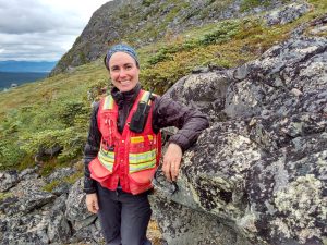 Dr Dawn Kellett
Research Scientist, Geological Survey of Canada, Natural Resources Canada. Adjunct professor, University of British Columbia, Queen’s University, Dalhousie University and Saint Mary’s University, Canada
Fields of research: Structural geology, tectonics, geochronology, thermochronology
Funders: Government of Canada, The Natural Sciences and Engineering Research Council of Canada (NSERC)
About geochronology
Geochronology is a field of Earth science focused on dating rocks, minerals and geological events to understand Earth’s history. Using techniques like mass spectrometry, radiometric dating and stratigraphy (looking at rock layers), geochronologists piece together the timeline of Earth’s evolution, from its formation to presentday. Their work contributes to various scientific efforts, including understanding past climates, locating mineral resources, and assessing environmental changes and hazards.
Geochronology is a rewarding field which offers a fascinating journey through Earth’s history and provides insights into its past, present and future. “It is tremendously exciting to contribute to piecing together Earth’s four billion years of history,” says Dawn. “There have been a few moments when I have calculated new ages from our samples and realised I am the first person to know something new about Earth’s past! That moment of discovery is a really special feeling.”
Technological advancements are allowing researchers like Dawn to conduct more accurate research. “I am very excited about the recent introduction of tandem mass spectrometers to geochronology,” says Dawn. “These instruments can take material separated from a sample by laser, pass it through a mass spectrometer (mass separation), pass it through a reactive gas (chemical separation) and then through another mass spectrometer.” This innovative method lets us researchers study samples that produce ‘isobaric interference’ – a phenomenon where two different isotopes have the same weight, making it impossible to measure them. For instance, the decay of rubidium to strontium involves the exchange of a proton and a neutron, but no change in mass. Traditional mass spectrometers struggle to isolate these isotopes, making tandem mass spectrometry a revolutionary tool for understanding the mysteries of geological time.
Geochronology holds promise for the next generation of scientists, offering opportunities to not only explore Earth’s history but also tackle pressing societal challenges. “There is tremendous opportunity for applying the field of geochronology to important societal issues,” says Dawn. “For example, it can be used to better understand how and where critical minerals (materials that are needed for green technologies and the digital future) accumulate in Earth’s crust, or to make good choices about geologically stable sites to store CO2 or nuclear byproducts. By equipping future geochronologists with the necessary tools and knowledge, we can empower them to make significant contributions to scientific discovery and address global challenges in the years to come.”
Pathway from school to geochronology
“For a career in geochronology, you can start with school courses in chemistry and physics,” says Dawn. “If you are interested in this field, you are probably curious about Earth’s evolution and the outdoors. Courses in Earth science, geology and physical geography will stimulate that interest!”
At university, you can specialise in geology, Earth and environmental science, or related fields. Courses in geochemistry and laboratory techniques are particularly valuable for aspiring geochronologists.
Look for workshops, camps or seminars related to geology or Earth science. These events may provide opportunities to learn from experts in the field and engage in hands-on activities or fieldwork.
Explore careers in geochronology
“Talk to your counsellor about which post-graduate schools in your area are offering specialisations in geology/ Earth Science,” says Dawn. “When you find one, read the webpages of the professors/instructors as they may be able to help you choose courses, and there may also be opportunities to shadow or volunteer in their lab.”
Geochronology is a rapidly evolving field, so it is crucial to stay informed about the latest research findings and methodologies. Websites like Earth Sciences Canada offer a variety of learning resources and information about career opportunities in geology.
Natural Resources Canada offers public outreach schemes aimed at inspiring young minds and promoting interest in Earth sciences.
Other websites like Mining Matters and Simply Science provide educational resources and information about careers in geology and related fields. Engaging with these platforms can help you explore your interests and learn more about the diverse opportunities available in Earth Science, including in geochronology.
Meet Dawn
Who or what inspired you to become a geologist?
By the time I finished high school, I knew that I wanted to study the natural world in some way. I began an undergraduate degree in oceanography. However, what really inspired me to become a geologist was an optional course that captured my attention, my love of the outdoors and wild spaces, and my deep interest in history. Once I completed my first field school, I was hooked.
What experiences have shaped your career?
Not all geological research involves field work, but many of us geologists were drawn to the discipline through a love of the outdoors and thrive on observing the natural world. I found that the study of geology gave me the opportunity to move through and study wild spaces that I would otherwise never have had the chance to see, from the Himalayas to the highest mountains in Canada, to the Arctic tundra, to desert landscapes. These experiences have taught me about leadership, resilience, safety and planning, and teamwork. I have also had formative experiences in labs, where I learnt problem solving, patience and creativity, and felt the rewards of automating a process or developing a new way to collect information. For me, field work and lab work go hand in hand. To be able to observe a rock in the field, take it back to the lab to analyse, and then calculate its age in millions of years is truly extraordinary!
You were chair of the Canadian Tectonics Group for several years. What did you gain from this role
Many of us scientists take on voluntary roles to run scientific societies and groups. It is these communities that take on the role of mentoring young scientists and students, and make sure that they have ample opportunities to gain experience, meet the research community, find peers with similar interests, and connect with resources like scholarships and grants. The Canadian Tectonics Group is a small but mighty community that does all of these things. Our crown achievement is our fall (autumn) workshop, in which students and experts gather together somewhere in Canada for two to three days to look at fascinating rock outcrops outside, share what we know and scratch our heads about what we don’t know, get to know our peers, and tell each other about our latest research findings. I was honoured to chair this group for several years. It gave me the chance to meet a whole generation of talented young people in our field of research.
What are your proudest career achievements so far?
My proudest career achievements have been hearing from others that they found my research useful and were able to build on it for their own work.
What are your aims for the future?
In the future, I aim to improve the way that our data are stored, shared and used by contributing to the development of well-curated databases. I am also aiming to learn more about incorporating artificial intelligence in my research and how to read and write software code. Younger generations have a huge advantage in being, on average, much more computer-literate than us older generations, so I’ll be looking to learn from and with you!
Dawn’s top tips
1. Keep up your sciences, even those hard courses.
2. Follow your instincts.
3. It is never too late to learn something once you recognise the need or desire to learn it.
Do you have a question for Dawn?
Write it in the comments box below and Dawn will get back to you. (Remember, researchers are very busy people, so you may have to wait a few days.)
Learn more about technological advancements in geological fieldwork:
www.futurumcareers.com/a-rocky-revolution-can-virtual-3d-models-transform-the-teaching-of-geology
0 Comments